Press release issued by the Isle of Wight Council
Revised plans for taxis during the St George’s Way improvement works in Newport have been published today (Wednesday).
In relocating the South Street taxi ranks to within Church Litten car park, the Isle of Wight Council said it had listened carefully to the views of local members and taxi operators.
The initial plan had been to create the temporary rank in nearby St James Street.
Councillor Ian Ward, Cabinet member for transport and infrastructure, explained: “In such circumstances there is never an ideal solution and we explored alternative options for the location of the taxi ranks.
“Multiple alternative locations were considered, including behind the library in Orchard Street, in Pyle Street and in lower High Street.
“However the options were limited practically by the one-way orders and traffic movement restrictions within the town and the requirement for taxis to be able to travel in all directions.
“We were of the view that on balance, the siting of the temporary rank in nearby St James Street was the best option in all the circumstances, however, we were happy to listen and take on board the views of local taxi operators and members.”
The current taxi rank outside Morrisons is required to facilitate the one-way diversion route and the rank outside Peacocks is needed to accommodate Southern Vectis buses, which have been displaced by the need to use Church Litten as a free-flowing diversion route.
When the easing of COVID-19 restrictions allow Southern Vectis to operate wholly in the bus station, the taxi rank will return to South Street outside of Peacocks for the duration of work at St George’s Way.
The scheme to widen St George’s Way is the latest phase of ongoing investment to reduce congestion in and around Newport.
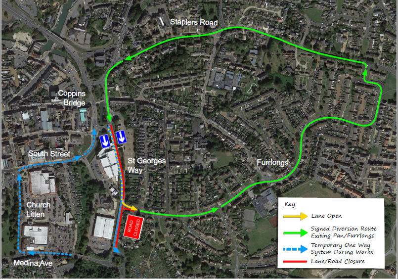
While access to and from Furrlongs will generally be available during the project, there will be periods when access will be restricted to allow works to take place across the junction.
The first planned closure of the exit from Furrlongs to St George’s Way is on Monday 15 March for two to three days. The diversion route for Furrlongs traffic during this period will be as per the diversion plan in the picture above.
Future diversions affecting the Furrlongs junction will be advertised onsite and via the council’s social media channels.
You can read more about the St George’s Way junction improvement scheme and view the diversion maps and other key documents here.