The installation of specialist equipment to monitor any movement around Leeson Road is to begin next week.
Data from nearly 30 pieces of equipment will enable the Isle of Wight Council and Island Roads to make informed decisions on the future of the strategic route between Shanklin and Ventnor. The equipment will measure any vertical and horizontal movement and also monitor any widening of existing cracks.
The council and Island Roads have also created a new webpage to highlight latest information on Leeson Road and other access issues affecting Ventnor given ongoing issues at locations such as Newport Road and Gills Cliff Road.
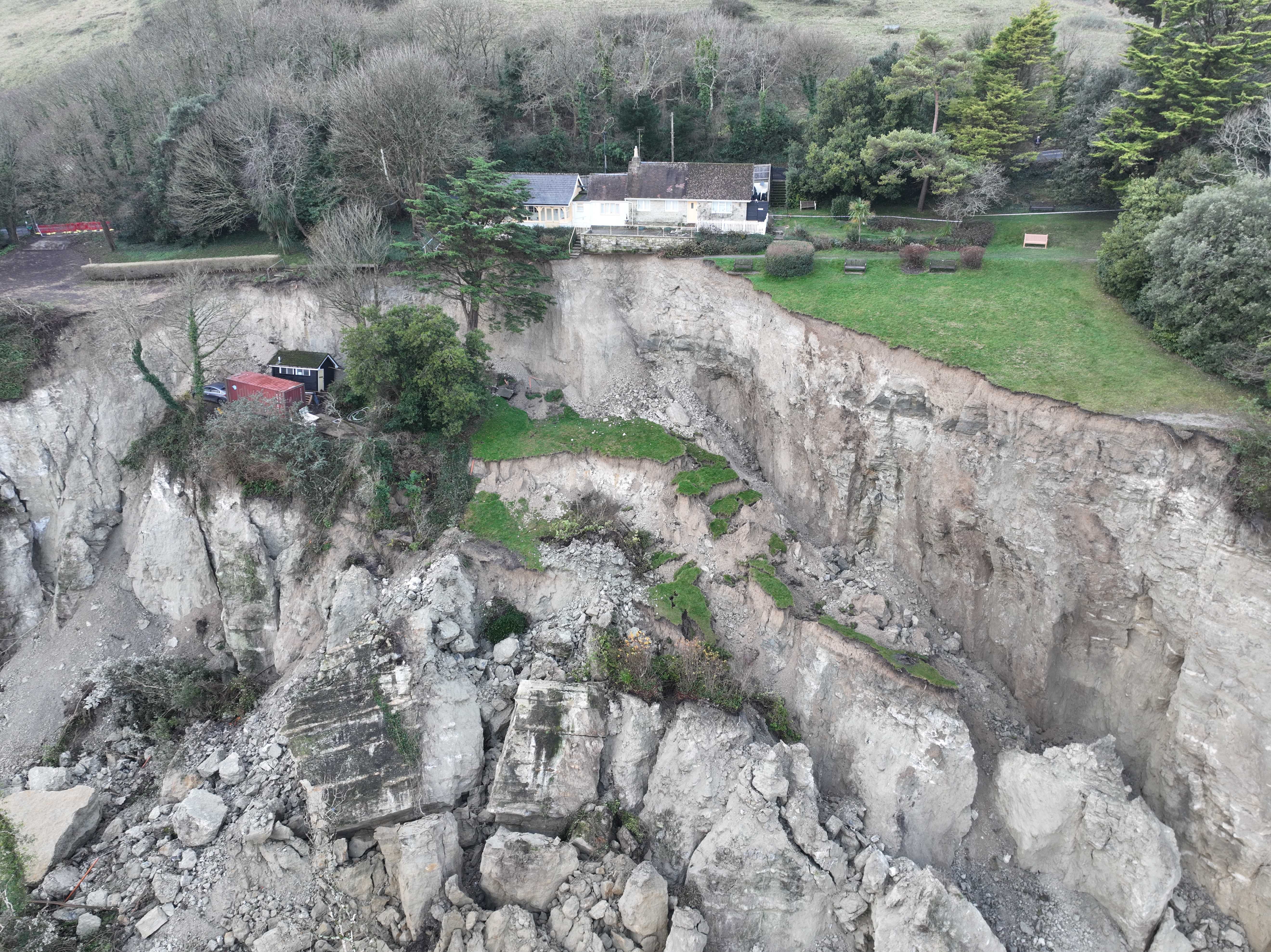
The upper section of Leeson Road has remained closed since a catastrophic landslip in December 2023 when 16 hectares – some 14million cubic metres of land – was displaced in what was one of the largest landslides recorded on the South Coast of England.
Leeson Road passes close to the back of the landslip and expert advice has recommended the road remains closed until more is known about the risk of further major movement. This is particularly so given that the heavy rainfall that was identified as a cause of the original landslip has persisted.
Subject to no further movement, favourable weather and the necessary permissions being given to install the equipment on private land, preparatory work will be undertaken followed by the installation of the equipment itself.
The type and number of equipment and the locations at which it will be placed has been decided in consultation with industry experts. The array comprises three extensometers to measure and record changes to visible cracking, 22 tiltmeters recording lateral ground movement, three global navigation satellite sensors providing remote monitoring of vertical and horizontal land movement.
Natasha Dix, Service Director for Waste, Environment and Planning said: “as we told residents at the public meeting in Ventnor last month, because of the catastrophic nature of the landslip and the ongoing heavy and prolonged rainfall, we need to understand more about the risk of further movement before we can make an informed decision on the next steps at Leeson Road.
“This equipment will be a crucial part of that process. While we cannot second-guess what that data will be, we can assure the community that we will continue to keep residents and businesses informed along the way. The new webpage is part of that, and we are also planning another public meeting in the town to discuss progress.”
The Leeson Road webpage, which includes answers to frequently asked questions, is available via www.islandroads.com and Leeson Road Ventnor landslip (iow.gov.uk)